Category:Umfolozi River
Jump to navigation
Jump to search
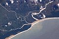
Afrikaans: Die Mfolozirivier ontstaan by die samevloeiing van die Swart- en Wit-mfolozi, en vloei dan tot by die St. Lucia-meermonding, waar dit deur herleidings van of na die meermonding gekeer kan word.
English: The Umfolozi denotes the river from the confluence of the Black and White Umfolozi Rivers to the St Lucia estuary, where it has been diverted to a separate mouth, though sometimes diverted to the lake again by a spillway.
| Object location | | View all coordinates using: OpenStreetMap |
|---|
river in South Africa  | |||||
| Upload media | |||||
| Instance of | |||||
|---|---|---|---|---|---|
| Location |
| ||||
| Mouth of the watercourse | |||||
| Tributary | |||||
 | |||||
Subcategories
This category has the following 2 subcategories, out of 2 total.
B
- Black Umfolozi River (5 F)
W
- White Umfolozi River (empty)
Media in category "Umfolozi River"
The following 4 files are in this category, out of 4 total.
-
 Arkiv för zoologi (1913-1914) (20148477109).jpg 1,936 × 1,370; 431 KB
-
 Natal province - descriptive guide and official hand-book (1911) (14574073508).jpg 4,016 × 2,760; 1.8 MB
-
 St Lucia Estuary ISS006-E-38182.jpg 3,032 × 2,006; 1.08 MB
-
 StLuciaWetland L7 07may01.jpg 540 × 540; 102 KB
_(20148477109).jpg)
_(14574073508).jpg)
